MAP: Turkish Safe Zone line (October 23)

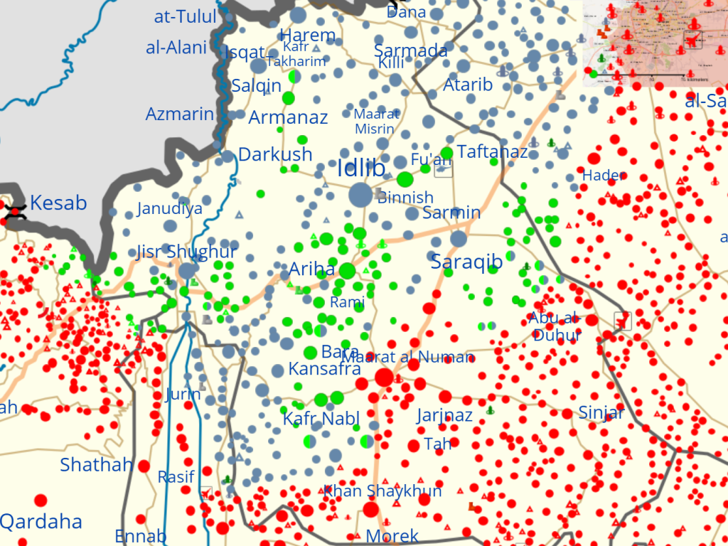
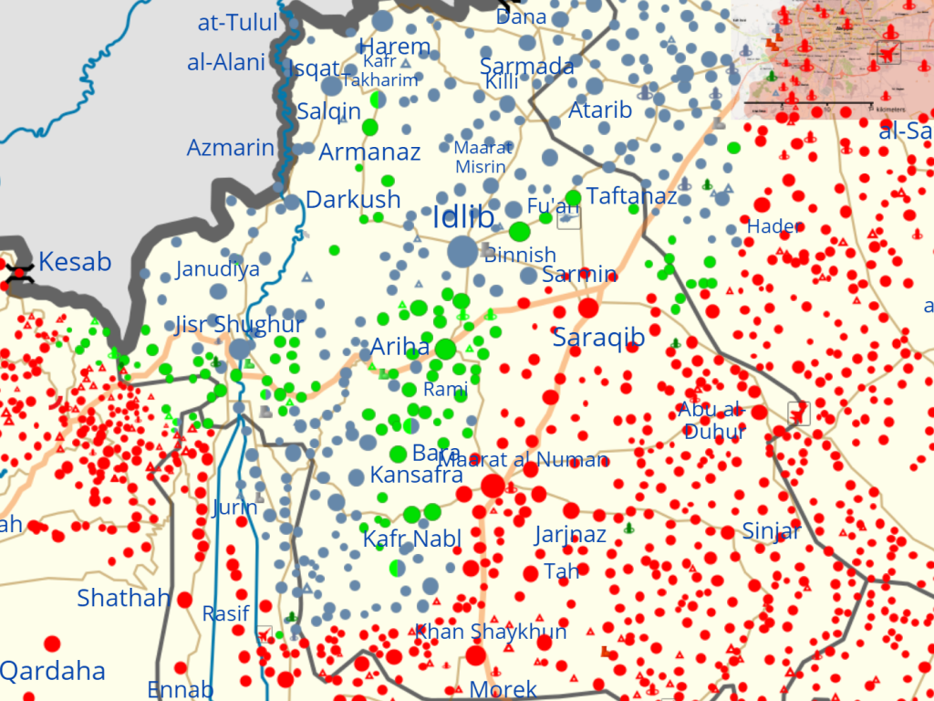
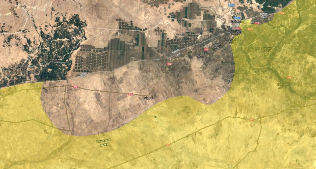
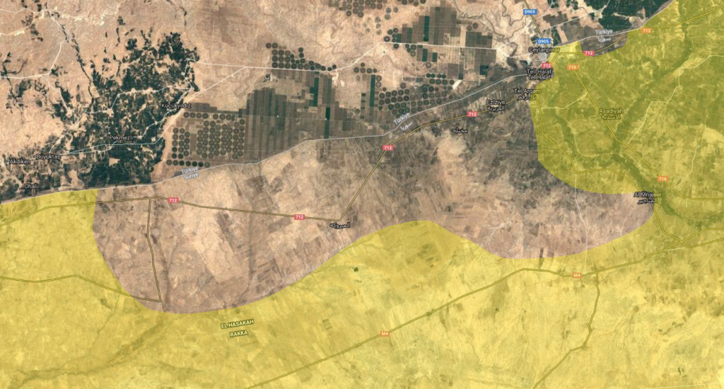
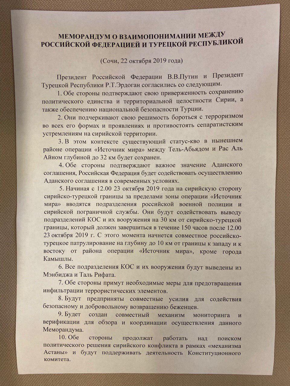
This is an interactive map of the 30-kilometer demilitarized zone to be entered by “Russian military police and Syrian border guards” of the Turkish safe zone in northeast Syria, as well the 10-kilometer line of “joint Russian-Turkish patrols” according to the Oct 22 Memorandum of Understanding between the Russian Federation and Turkey (in English and Russian).

Note that all of the M5 highway is included with the exception of Ayn Issa (which technically is outside the zone and is occupied by Syrian government troops). Tell Tamer, another town with government troops inside, also falls just outside the zone.

Important sites located inside the zone include Sharaqraq, Qantari, and Turkmen Ali Beyli. The “greater” safe zone, which represents the full Turkish claim of 32 kilometers south of the entire border from Jarabulus to Iraq, also includes the Qara Qawzak bridge, which would mean people in the Autonomous Administration would have only one route crossing the Euphrates River (the Tishrin Dam bridge) to travel to and from Manbij. Even under the “greater” safe zone, however, the Autonomous Administration would maintain control over the Arab towns near the line such as Sarrin, Jurniyah, Mahmudli, Khunayz, al-Hishah, Tall Siman, and Qaltah.

The Sochi Memorandum also states that “All YPG elements and their weapons will be removed from Manbij and Tal Rifat.” This would significantly alter the balance of power in Aleppo province, forcing residents in the area to choose between living in Syrian government territory or Turkish-backed rebel control.

Exclusive: Al-Sanadid Forces have not yet decided to deploy to fight Turkey

Syrian War Daily can confirm that Al-Sanadid Forces (Quwwāt as-Ṣanādid), an Arab militia of the Shammar tribe allied with the Syrian Democratic Forces, has not yet decided to deploy any forces to assist their Kurdish partners in fighting the Turkish invasion of Rojava. Although Al-Sanadid is at a heightened state of alert, the group has troops standing by at its traditional strongholds al-Yaarubiyah and Tell Hamis.

The Turkish ground forces have not yet crossed the border en masse, although special forces have tried and failed to infiltrate SDF positions along the border (at Bir Ashiq for example). Meanwhile, Turkish Air Force planes have bombed Tal Abyad, Suluk, Qantari, Bir Ashiq, and Hammam Turkman. Pro-SDF forces are also clashing with Turkish-backed militias west of al-Bab in one of the last SDF positions in northwest Aleppo.

February offensive sees much of Idlib province fall to government (map)

A recent offensive by the Syrian Army saw the government capture the important rebel cities of Ma’arat Numan and Saraqib. This places the government within striking distance of the de facto rebel capital Idlib, a city which rebels seized in March 2015. With these latest large advances, Assad’s forces could be on track to take the city back five years after they lost it.

Maps: Syrian government captures large rebel pocket, clearing all of northern Hama

The Syrian Army has now taken all of northern Hama Governorate from rebel forces, creating a new frontline inside the southern part of Idlib Governorate 25 km shorter than before (and freeing up many front line guard troops for future operations). The government took from rebel forces the strategic city of Khan Shaykhun, as well as the devastated towns of Latamina, Kafr Zita, and Morek. The Turkish Army observation post in northern Hama has still not been evacuated, and is now surrounded by Syrian Army troops and tanks at close range (as short as 100 meters). The moderate rebel group Jaish al-Izza has lost its territory due to this battle. This leaves jihadist group Hayat Tahrir al-Sham in control of the front line with government forces, with a few exceptions in the southeast of Idlib (such as the Free Syrian Army Mountain Hawks Brigade and the National Liberation Front).

Map update: Battle of Northern Hama – 22nd of August 2019

Map of northern Hama governorate. The Syrian Army pushed south of Khan Shaykhun by capturing the town of Sayad and the Khazanat base from rebel forces. These actions tighten the siege on rebels in northern Hama, making it harder for them to make a break-out escape.
The government has opened a humanitarian corridor for civilians trapped in the pocket to escape to government-held territory at Suran to the southeast of the area.
If and when the rebel pocket in northern Hama collapses or is evacuated, the Syrian government will shorten its frontline with rebel forces, allowing them to concentrate more troops along a smaller area and stop the repeated rebel attacks on pro-government towns.

Dernières nouvelles: L’armée syrienne sont entrées à Khan Cheikhoun et prend une partie de la ville (avec des cartes détaillées)

Carte de la contrôle territoriale dans la ville de Khan Shaykhun du gouvernorat d’Idleb, lundi matin, 19 août.
Carte de la situation militaire actuelle au nord du gouvernorat Hama et au sud d’Idleb, lundi matin, 19 août.
Carte de la contrôle territoriale dans la région d’Idleb, lundi matin, 19 août.

L’armée syrienne a pris deux postes de contrôle autour la ville de Khan Cheikhoun le soir 2019-08-18. Ensuite, peu après minuit, les troupes armées avaient lancé un assaut au nord de Khan Cheikhoun et ont pris une partie de la ville.

Le nombre du combattants morts des dernières 24 heures approchant quatre vingt-dix. L’ensemble de la région tenue par les rebelles au nord de Khan Cheikhoun est sous l’assaut écrasant du gouvernement, soutenu par des frappes aériennes sans arrêt de chasseurs à réaction et d’hélicoptères. Presque une mille civils syriennes sont morts au cours des quatre derniers mois, presque tous était dans les zones contrôlées par les rebelles.